What if tomorrow, it becomes possible to walk around France, in 3D, from your sofa? This is what the IGN is working on with its LiDAR HD mission which consists of making laser surveys of the entire territory. A way to influence public policies and better fight against climate change, among others.
You may have lost yourself virtually in the catacombs of Paris thanks to the prowess of LiDAR technology which allows you to scan your environment in 3D. Soon, you will be able to explore all of France in the same way thanks to the work of IGN.
The state-owned company has just launched its HD LiDAR program which aims to offer ” very precise 3D mapping “Of the whole of French territory (except Guyana) by 2025. A mission that will shed light on public policies and which can also be used” as a development engine for SMEs or as a breeding ground for scientific research »According to the institute.
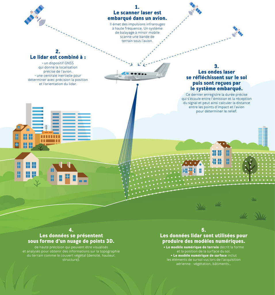
Concretely, several planes equipped with laser scanners will crisscross France by scanning the relief of French countryside, cities and roads. The operation is scheduled to last 5 years, will require 7,000 flight hours over the country, generate 3 petabytes of data (3 million gigas) and cost 60 million euros. What to give an idea of the scale of the project.
A tool to fight against climate change
” The Lidar HD program will increase the knowledge of the territory necessary for the deployment of public policies “, Points out the IGN to justify this investment. Loïc Gondol, project manager, discusses the genesis of the project with Numerama: “ It has long been known that LiDAR can be useful for many public policies. IGN has used it occasionally for about ten years along certain rivers and coastal areas to measure the risk of flooding. “. By establishing a hyper-precise topographic profile of certain areas and crossing it with meteorological data, it becomes possible to better react to climate risks.
But this is not just about the rising waters. ” With LiDAR we can also visualize the risks of landslides, runoff or avalanche », Loïc Gondol list. After the passage of storm Alex at the end of 2020, the IGN made surveys in the affected territories to allow civil engineers to better examine the area. ” A statement at 10 points per m2 [densité retenue pour la mission, ndlr] also allows to have an evaluation of the forest biomass », Adds the manager.
LiDAR can also be useful in the fight against climate change: “ In urban areas, it allows to better model the roofs of buildings to install photovoltaic panels “, Illustrates Loïc Gondol who imagines the creation of a” solar cadastre »To better exploit the potential of renewable energies.
1 million euros for a LiDAR sensor
Beyond these climatic issues, a 3D representation of the territory can also help the development of agriculture thanks to a more detailed knowledge of the land. Better modeling buildings and houses could also make it possible to better understand the living area and thus lead more efficient urbanization policies. ” We do not know all the uses that will be made with this data. », Admits Nicolas Lambert, head of the partnerships and institutional relations department at IGN. ” This is good news, it means that some will be discovered. We can generate interest and provide new funding », Rejoices the manager.
But before thinking about use, a 3D map and the fight against global warming, we must already succeed in collecting and correctly processing this data. An interactive map shows the progress of the project and it is quite clear that the mission will take a few more years. ” Doing this program in 5 years is extremely ambitious », Explains Nicolas Lambert, who adds that the IGN works with subcontractors from the private sector.
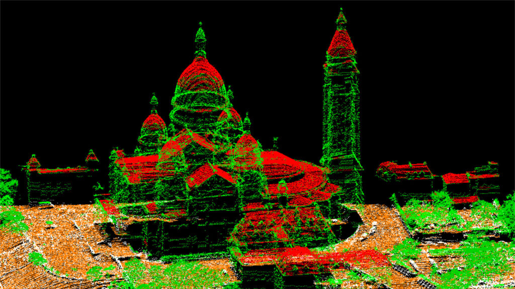
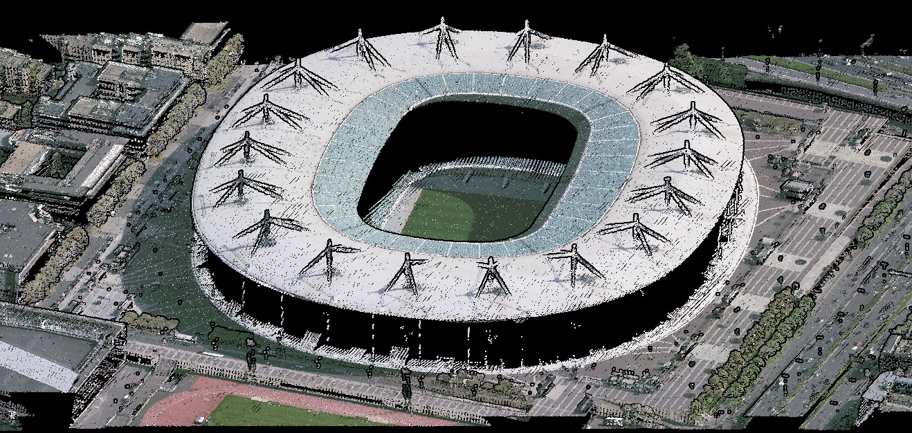
The result of a LiDAR scan is a ” A cloud of dots »On which we can then apply textures from aerial photography to represent a building in 3D. But the tools that can do this are expensive. ” A LiDAR sensor costs around 1 million euros. This is not the same tool that equips the iPhone 12 Pro », Jokes the manager. ” It’s a bit the same difference between a GoPro and the cameras we use for aerial photography. “
Open data to everyone, even Google
Once the acquisition is made, this data will have to be processed again. And unsurprisingly, to sort, classify and store these point clouds, IGN will call on artificial intelligences capable of processing large volumes of data and deriving exploitable models from them. ” AI can have a real plus in improving automatic processing performance », Explains Loïc Gondol.
Then, this data can be integrated into various public projects such as GéoPortail, the IGN mapping service, but also used by everyone. The different datasets will be open and free to access to encourage SMEs, start-ups and private sector players to use them in order to create new uses. ” Encouraging uses starts with making this data available », Summarizes Nicolas Lambert.
Asked about the possibility that a Behemoth like Google could use this data from the public investor, Nicolas Lambert took a step aside: “We do not know if Google will use it, in any case it is up to the French carriers of the open-data policy to support French SMEs and startups in the development of services. », Concludes the manager.
Infographic: how does a LiDAR statement work?