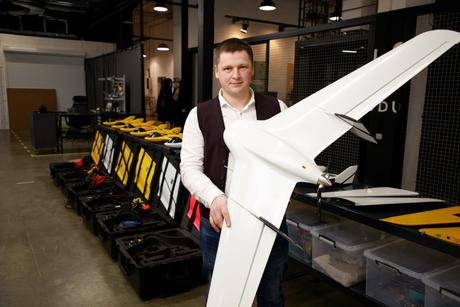
Ukrainian company Culver Aviation introduced Menatir, an innovational automated aerial surveillance system powered by UAVs, at an exhibition in Las Vegas. The system provides government agencies and companies with the ability to continuously acquire and handle real-time information from the surface of our planet.
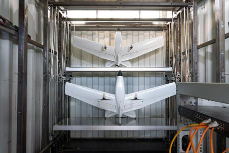
Menatir is a network of base stations built as typical 20-foot containers with unmanned aerial vehicles stationed inside. The containers shield the drones and ensure that they take off, land and complete missions, as well as recharge and transfer the data they collect – all in an automatic mode.
Menatir enables complete aerial monitoring of any object in real time, 24 hours a day, 7 days a week and all year long. This ensures that the system is well-suited for environmental security, municipal utilities and infrastructure services, as well as fire suppression in forests, residential communities, and so on.
Irrespective of the number of base stations in the Menatir network, it requires only one technician to manage it, working from any location in the world.
What is the company that invented Menatir?
Menatir is a multipurpose UAV-based aerial observation network system. The Menatir system was established by Culver Aviation, which since 2021 is a member of the international technological holding TECHIIA.
Culver Aviation was founded on the background of ITEC, which had existed on the Ukrainian market since 2014 and was acquired by TECHIIA Holding.
Capabilities of the Menatir aerial monitoring network system
1. Video surveillance in real time
The Menatir system is dedicated to organizations that need eyes in the sky. It offers real-time, high-definition video for around-the-clock monitoring of the air surface. The system can be used to help detect leaks and corrosion in pipelines, inspect power lines, evaluate damage from natural disasters, supervise hard-to-reach areas, find pavement damage, and much more.
2. Orthophotography and 3D mapping
Centimeter-accurate aerial reconnaissance for easy and productive mapping and surveying. The drone system provides high-resolution imagery combined with centimeter-accurate georeferencing to create highly accurate orthophoto plans and 3D models.
3. Multi spectral mapping
Menatir provides an advanced multi-spectral mapping of agricultural crops, orchards, green areas, and water bodies. The UAVs system provides reliable data to determine yield potential, water stress, irrigation efficiency, location of drainage lines, weeds and diseases, fungal diseases, and much more.
4. Thermal imaging monitoring
The Menatir system detects landscape fires in their early stages, which minimizes the negative impact on the environment and reduces fire damage restoration costs. It can be used to check the temperature regime of power line components, analyze the performance of solar panels, and in many other tasks.
5. Air quality monitoring
Menatir can be used for air analysis up to 2000 meters above the ground. Georeferenced gas concentration data, along with software to analyze it, help identify the sources and movement of air pollutants.