The advantages and utilities currently offered by online applications such as Google Maps and EarthThey are beyond any doubt. Both at home and in the car we can use these software solutions for multiple functions related to positioning. Now we are going to see how to measure distances in both programs.
Surely on many occasions you have used Google Maps to check an address or even see its real appearance. Likewise, most of us carry it on the mobile to be able to benefit from all its positioning advantages when traveling in the car. But surely on many occasions we have wondered how to see the real distance between 2 places on this platform.
Well, the first thing we should know is that this is a fairly simple process to carry out, as we will see below. We have to know how to obtain this data, so we will show you the steps to follow later.
How to measure distances on Google Maps
First of all, we are going to focus on the aforementioned platform google maps that allows us to easily measure any distance between two points. To do this, it provides us with a series of integrated tools with which we will obtain the shortest possible distance in a straight line. At the same time today we have the possibility of add several points to follow a specific path.
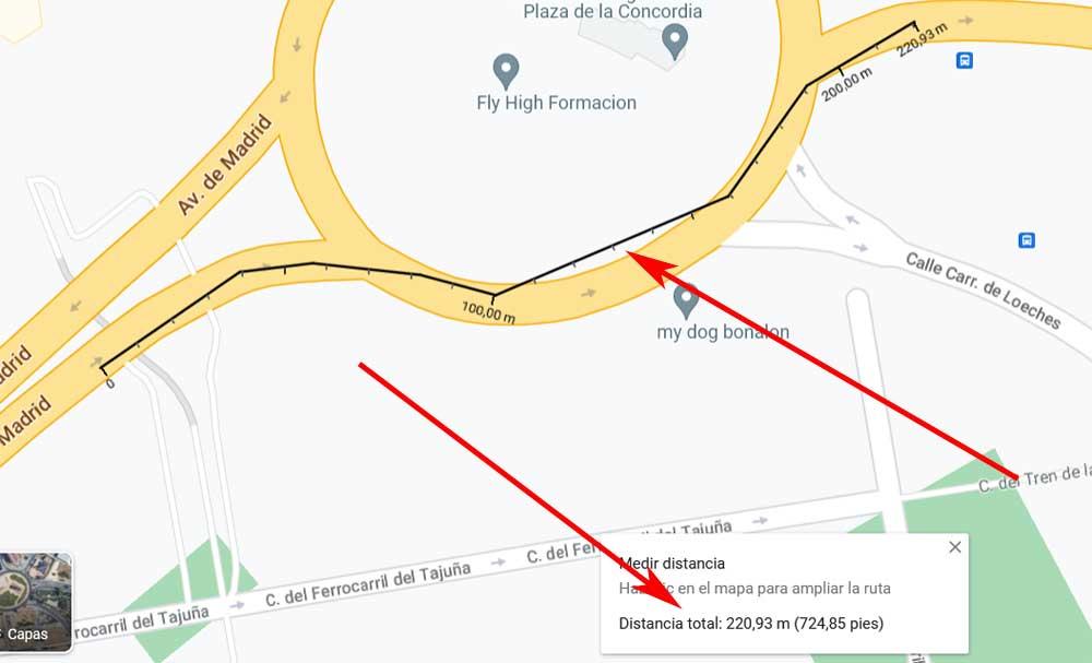
To achieve this, first of all we click with the mouse on the starting point and select Measure distance in the contextual menu that appears. This is found by clicking the right mouse button once the mark is made.
Next, we just have to click on the second point, which will be the destination, on the map. At that time, Google Maps will automatically show us a pop-up window with the distance between the two. If we need to add more points in this measurement, we simply click on them moving around the map.
Measure the distance between two points in Google Earth
In the event that we are more accustomed to using Google Earth, we can also repeat this process that we have just shown you here. The first thing to keep in mind is that this platform is more detailed than Google Maps. But with everything and with it the measurement of distances, which is what concerns us in this case, works in a similar way.
Once we have launched the application in our favorite web browser, click on the button that says run earth. Next, we click on the Search icon that looks like a magnifying glass and type the location that we want to see on the screen. To start measuring, all we have to do is select the ruler-shaped icon at the bottom of the left sidebar.

To finish, we will only have to mark the different measurement points so that Google Earth shows us the distance in real time. This will take place both in the measurement line and in a small window that appears on the screen to make the information even clearer.